BAR HARBOR—“It’s a draft,” Dan Bannon, project manager for GEI Consultants, said to Harbor Committee members as he presented the masterplan for the ferry terminal area on Route 3, Monday afternoon. “Remember it’s a draft.”
That draft of the Ferry Terminal Masterplan was on the agenda and five members of the 11-member committee heard it, but there were not enough members attending to have a quorum, which means that there will be no official minutes of the meeting or actions taken. It was the second consecutive meeting that lacked a quorum. The meetings tend to start at 4:30 and have lower attendance in the summer when many members have less flexible working schedules.
Committee member Kaitlyn Mullen requested that the draft plan presentation be posted and available to the public via the Harbor Committee’s page on the town’s website. It is not currently posted. As of press time, the town did not have a copy of the presentation according to Harbormaster and Special Services Lieutenant Chris Wharff.

THE SITE
The site was built in 1956 for the Bluenose. In the early 1980s, it was adapted for the Bluenose 2 and the Cat. Service stopped in 2009.
The town acquired the site from the Maine State Ferry Service in 2019. Multiple studies were undertaken about the use of the site. The Cat began ferrying passengers and vehicles again from Bar Harbor to Nova Scotia, Canada in 2022.
In 2020, the pier was inspected by GEI, both above and underwater. The pier structures were found to be in a severely deteriorated state. The piles under the pier were particularly weathered, including one that was almost completely deteriorated.
The Bar Harbor Town Council voted to demolished the pier in 2021. In 2022, limited repairs to the north pier occurred to allow continued use by the Cat. In 2022, the town received a grant to create the master plan, which is what GEI is was presenting a draft of at the meeting.
THE PROJECT AND THE USES
The project goals include:
Creating a cohesive masterplan for the marina;
Expand public access to the water;
Support the working waterfront;
Provide public open space;
Economic uses.
“There are different potential futures considering whether or not the town decides to renew that lease or not,” Bannon said.
One of those potential uses which is not currently represented in the plan is cruise ship tendering. That would likely require a dedicated dock without any other boats on it.
From the audience, Town Council Chair Valerie Peacock said the town hasn’t been tendering for a while, but the plan needs to have enough flexibility to have that so that the town can tender if they want to.
“It depends on the level of visitation and if the town wants to go into the tendering business again,” she said.
“The cruise ships come with busses and transportation,” Peacock said, so the plan would need to have a space for busses, too. “At some point, we need to decide or prioritize if we want to make that happen.”
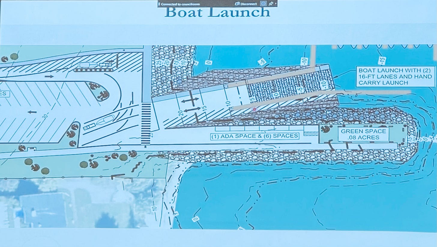
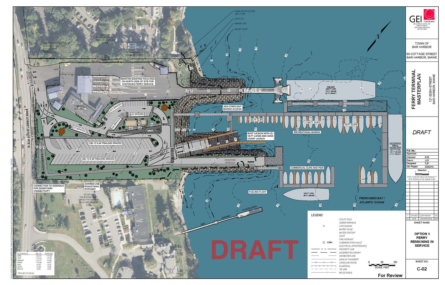
Another potential use, which currently doesn’t exist in full form, would be realigning the boat ramp so that fishing boats can line up with the ramp and unload traps or gear directly onto trailers. Though the current draft configuration has a boat ramp, it can’t be used in this way. The proposed boat ramp is 240 feet and a 15% slope, but it’s the lack of deep water on either side that doesn’t allow this use.
According to committee member Jonathan Carter and Harbormaster Chris Wharff, there isn’t a fully functional launching ramp currently in town despite the one at the end of West Street.
“Only on good days,” Carter said. “At times it is very dangerous.”
He added, “It’s usually so damn rough. Most of the times, the seas are almost washing into the boat while you use it.”
Carter had multiple ideas about potential ways to site the ramp so that it’s more useful to those who fish and lobster commercially. Bannon said they’d explore those options.
Chair Jeff Miller also asked about potential moorings for sailboats.
THE PROJECT TIMELINE
The master plan project kicked off in September 2022. Final deliverables will be submitted by December 31 of this year, Bannon said.
The plan, however, will still not be specific and overly detailed.
The phasing in of the plan, once completed and accepted by the Town Council, could vary.
FLEXIBILITY AND DESIGN
GEI’s Travis Pryor gathered stakeholder feedback, and some of the major things they heard were that they needed to provide options for phased implementation.
“It’s very important we consider the potential future for the facility,” Bannon said.
Good separation between commercial and recreational marina use was important, he said. So was the ability for both trailered boats and hand-carry paddle craft to launch. Many people wanted to have a small-vehicle-rated pier. That way trucks can get out and hoist near vessels. People wanted parking, for the area to be bike and pedestrian friendly, as well as waterfront open space for public access.
Bannon summed it up as having “flexibility of future development, accommodation of mixed uses, and sustainable development.”
Components of the design include:
An all tide boat ramp;
Floating docks in multiple sizes;
Minimizing exposure to water and wind.
“The site is relatively well positioned in terms of sea level rise,” Bannon said. This is because it is at a high elevation compared to the water.
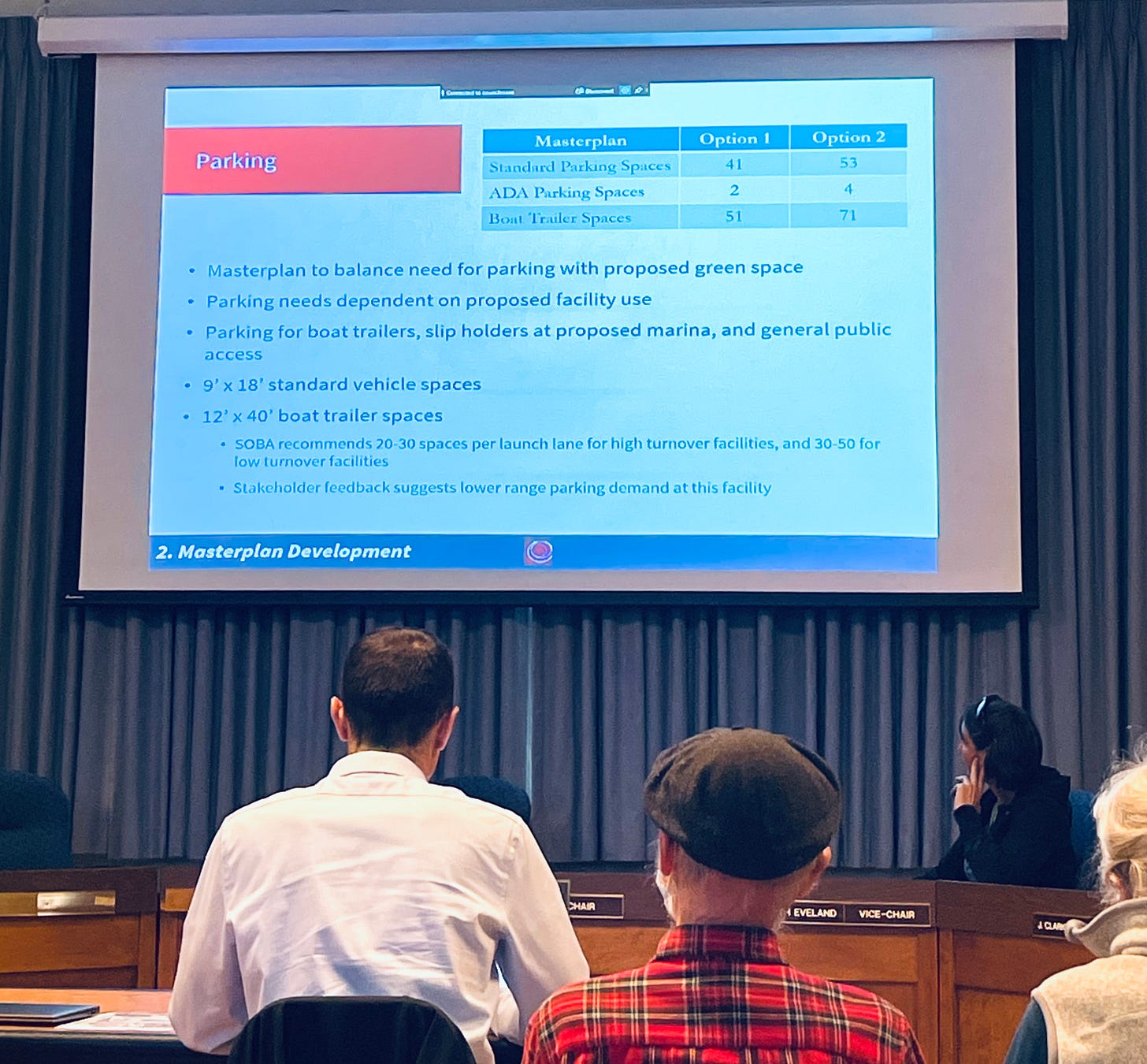
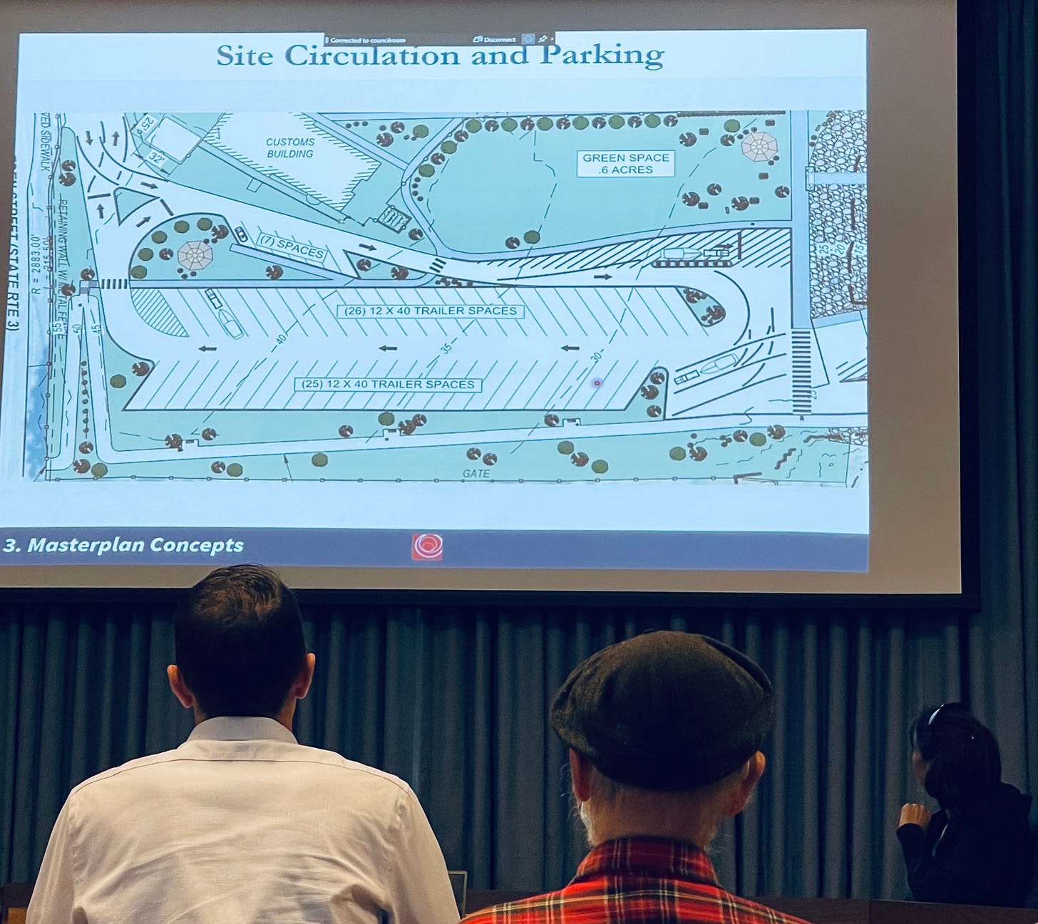
Parking depends on the use. Seasonal use (people hauling their boats in and out at the beginning and end of the season) rather than daily use (people hauling in boats and kayaks every day) is part of the reason for the variety in the number of parking spaces. There are multiple boat trailer spaces.
Peacock asked what they meant by commercial use. Bannon said he meant commercial fishing use. She didn’t think there was enough parking for a commercial tour. She also couldn’t imagine 50 boat trailers currently needing that many spots that are in the current draft plan. She said, “You’re saying that fifty feels low. That feels insane to me.”
Option 1 included 51 spaces for boat trailer parking, 41 standard parking spaces and two ADA parking spaces. Option 2 included 71 trailer spaces, 53 standard parking spaces and 4 ADA spaces.
Wharff suggested that since the plan is phased in, they can see the level of demand for trailer spaces (and other spaces) as time goes by and the area is used.
The site is 1.4 miles from Bar Harbor and it is proposed to include a shared-use pathway that connects to the existing one along Route 3
They have not specifically identified what the buildings might be at the site, but they have put in building pads as part of the proposed conceptual master plan.
“There’s a wide range of options as to how the open space gets developed,” Bannon said.
It could be rustic or have more hardscaping.
“It’s really to give direction toward options, but the final design selections would occur at a future time,” Bannon said.
There is also a rain garden potential plan to trap and filter stormwater runoff and also to create more of a living shoreline to soften the upper edge of the shore rather than just having rip-rap just come up to the parking lot.
“A key element to these plans is we wanted to give you options that are adaptable,” he said.
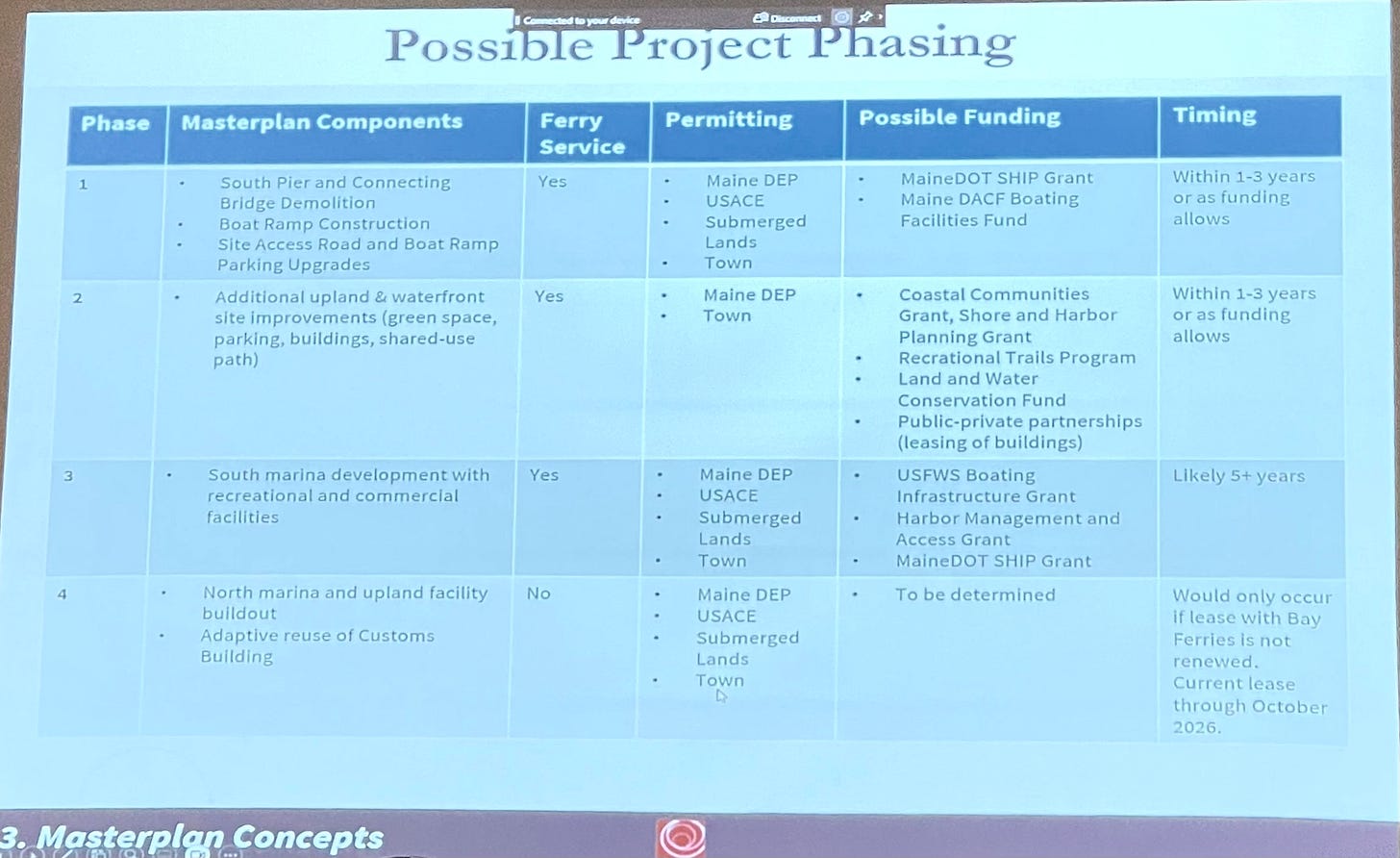
Part of the reason for those multiple options are that the town does not know if the lease with Bay Ferries (the CAT) will continue past October 2026 or if the town will eventually want to tender cruise ships to the site.
POSSIBILITIES
Concept A is one of the least complex. It provides for a boat launch, marina, one-way traffic pattern, and green space and it assumes continued ferry service, so that a portion of the parcel remains untouched and undesigned.
“A lot of this is greenspace,” Bannon said.
Concept B would be if the ferry service is not continued. It adds an additional fixed causeway and commercial uses on that north pier.
Bannon also suggested a possible way to phase in the project.
Creating the marina could be phase 3. Phase 4 could be further pier demolition and building the north side of the marina if the CAT was no longer there.
“There could be many other options,” he said, including having the phases be broken down into subphases.
“I think phase 1 would be a very good” and easily achievable option that could occur in the next 1-3 years with a Maine DOT grant, Bannon said. The other phases would be more extensive and costly. Actual marina development is likely five years out.
Questions from the board focused on where the fuel docks and hoist locations would be and what permits would specifically be needed for those. There is a potential for the town to have fuel earlier and have it on the pier rather than the dock.
Bannon said GEI imagined the hoist would be on the corner of the fixed pier. They will identify that in the plans. The pier could be built in advance of the full marina as an early option.
There wouldn’t any large-scale dredging for the project.
“There’s definitely quite a few grant funding options that the town could look at,” Bannon said. “There’s quite a bit of grant money out there right now.”
“It’s a tremendous opportunity for the town,” Bannon said.
Apologies again for the quality of these images. We’ll update this story when we receive the presentation, which will allow me to have clearer images than what I snapped at the meeting.
Photos: Carrie Jones


