When Is a Site a Brownfield?
Fill at MDI YMCA Would Most Likely Have to Be Replaced To Develop Further
BAR HARBOR—Volatile organic compounds (VOCs), semi-volatile organic compounds (SVOCs), polychlorinated biphenyls (PCBs), pesticides, herbicides, and certain metals are all among the pollutants being tested for at the town owned parcel of land at 21 Park Street where the Mount Desert Island YMCA resides.
Maine Department of Environmental Protection employee David L. Chapman, who is the project manager and a hazardous materials specialist was on the site Monday. Chapman explained that a couple of years ago the MDI YMCA had some soil testing completed to see if it was acceptable material to build upon. During those tests, some contaminants were present, but that was not what the YMCA was specifically testing for, so it was not a comprehensive contaminate test.
One potential contaminate found during those earlier tests was coal dust. During her tenure as the town’s sustainability coordinator, Laura Berry reached out to Chapman to see if the town and the YMCA could take advantage of the Federal Environmental Protection Agency’s Brownfields Program to test the soil and determine the level of contamination.
According to Chapman, Maine receives roughly a million dollars a year from the federal government for brownfields’ testing. Chapman further explained that a brownfield is any piece of land where development has been hindered by a real presence or a perceived presence of contaminants.
Maine defines a brownfield as "real property, the expansion, redevelopment, or reuse of which may be complicated by the presence or potential presence of a hazardous substance, pollutant, or contaminant."
The state site goes on to say that, “Essentially, a brownfield site is a property where re-development is impeded because of contamination, real or perceived.”
The State of Maine, through its brownfields grant, is paying for the soil testing that is currently ongoing at the town-owned land where the YMCA sits.
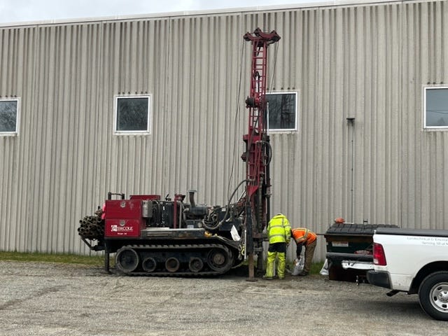
By 11:30 a.m. on Monday, April 24, the first day of planned soil boring, S.W. Cole Explorations already had 19 of the 27 borings completed. From each soil boring, two samples were taken. One sample was taken at the “accessible” depth, which is considered to be 0-2 feet in depth, and the second sample was taken at the “potentially accessible” depth, which is from 2-15 feet in depth.
Each sample was then packaged on site for shipment to a testing laboratory, but a portion of each sample was actually tested after it was taken at the site. On the tailgate of a pickup truck, an employee of Beacon Environmental Consultants packaged the samples for shipment to the lab.
That same person was also placing a small amount of each sample into a foil bag so that if it contained any airborne contaminants, they could have a chance to come out of the soil but be captured in the bag. The bag would then be opened enough to allow any gaseous contaminants to be tested by a detector that could provide some preliminary results.
Chapman explained that most of the contaminants that were being found were located in the fill area of the soil. That is the area that they were having to bore through before reaching native soil, which Chapman described as a silty clay. Most of the soil borings were at least five feet deep before reaching that native soil level.
The fill on top of the native soil has been around for a long time and nobody can really say where it came from, according to Chapman, and many activities have taken place on top of that fill over the years. Prior to the land being given to the town by the National Park Service, it was used as a storage area for park vehicles. This could have led to contamination via gasoline and diesel fuel spillage/leakage, solvent spillage/leakage, or anything else related to vehicle storage and maintenance.
Chapman stated that the results of the tests will most likely not be complete and written up for a month or two but once they are, they are public record. A copy of the results will be sent to the town and the YMCA and should be available to anyone who has an interest in them.
For now, though, Chapman conveyed that if the YMCA wishes to build anything on the property, then the main concern is the quality of the fill itself. What was used in the past is not acceptable fill today and they were finding it contains red brick, coal dust, and soil types that do not make for a stable foundation.
As the two men that were running the boring rig worked, they switched from what appeared to be a large drill bit to a thinner solid shaft of steel. This shaft was pounded into the ground by a weight of a certain size and every time the weight hit the shaft, the distance that the shaft sank into the ground was measured. Chapman relayed that the shaft was sinking too great a distance per strike of the weight to have stable fill on top of the native soil.
To build on top of this soil, the YMCA would have to remove the soil down to the native soil level, approximately five feet, and then bring in new acceptable material as fill. That removal process, while daunting and expensive by itself, doesn’t consider any contaminants that may be found to exist at unacceptable levels which would make the procedure more costly.
Disclosure: The author of the article and the editor are immediate neighbors to the MDI YMCA.


