Where Will All The Houses Go?
A deep dive into Bar Harbor's balance between infrastructure expansion and resource protection
BAR HARBOR––According to the Bar Harbor Housing Analysis (December 2022), created for the town by RKG Associates, Bar Harbor is estimated to need 616 new dwelling units by 2033. This number is broken down into estimates of 94 new owner-occupied units and 522 new renter occupied units.
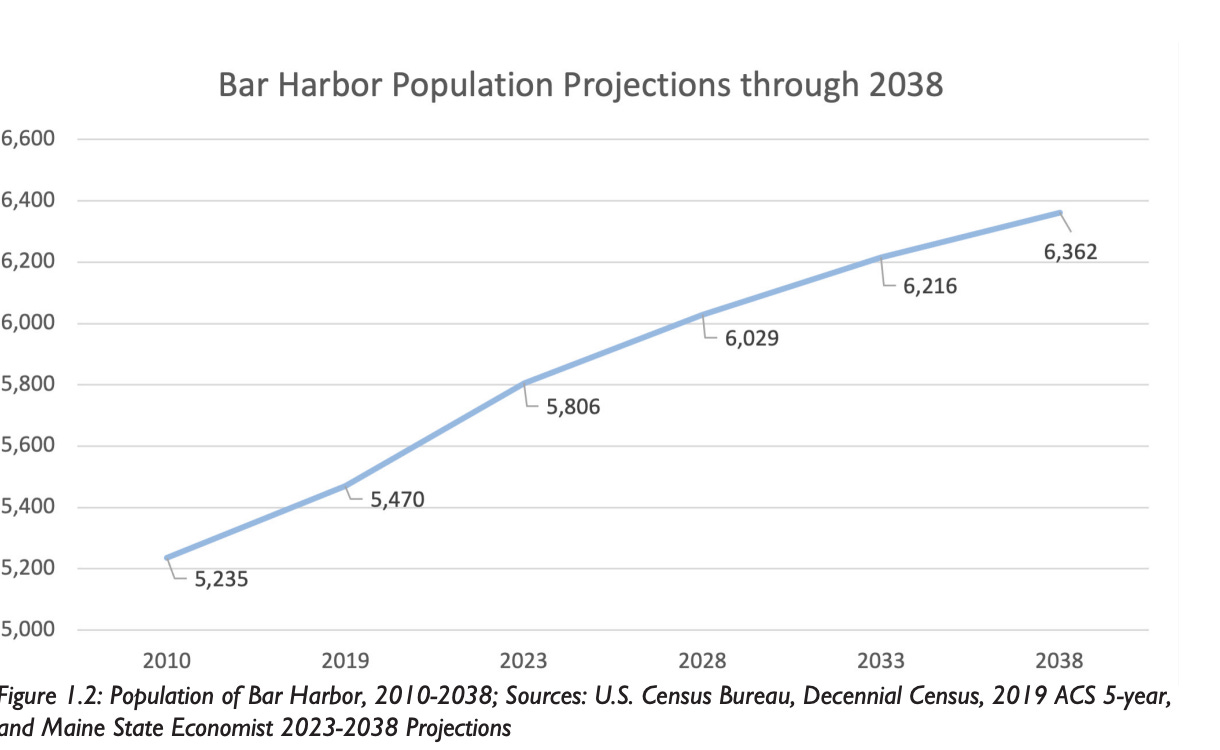
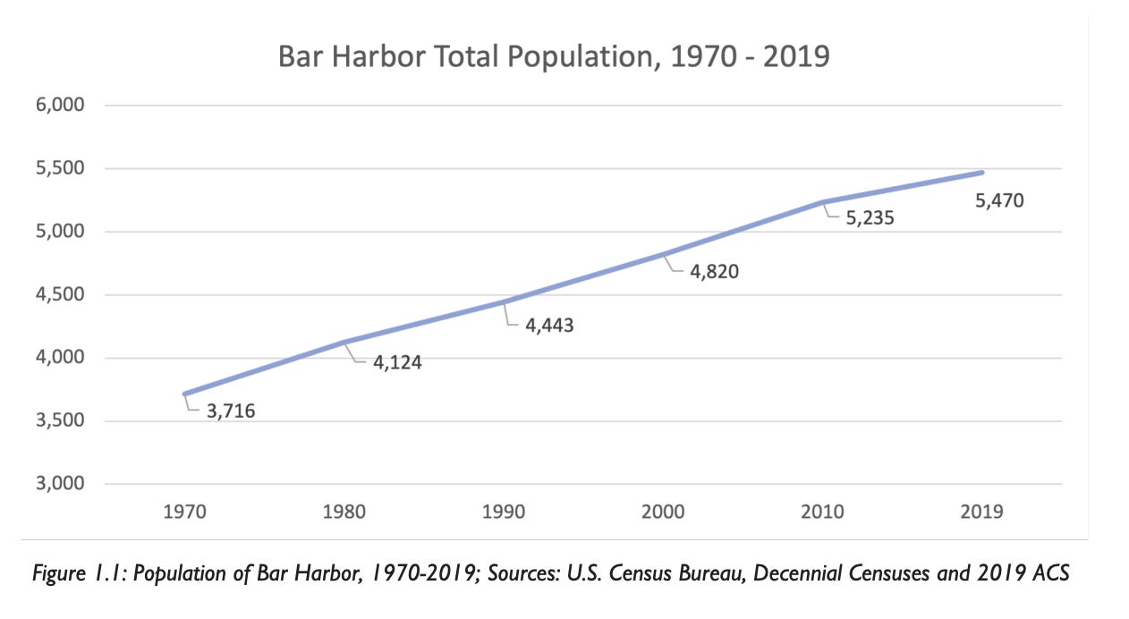
The town’s Existing Conditions Report (2022) predicts the population will continue to increase.
Unless you are purposefully living off the grid, every dwelling unit needs a standard water source and a method by which the used wastewater exits the unit. Currently, approximately 16% of the town’s population is served by town-provided water and approximately 5% is served by town-provided sewer infrastructure.
The majority of the properties served by town water and sewer infrastructure are located in the more densely populated downtown areas with each service extending roughly to DeGregoire Park to the north and the Jackson Laboratory to the south. For the most part, any buildings that have water and sewer beyond those points are utilizing private wells and septic systems.
In May of this year, the Comprehensive Planning Committee held four visioning workshops for the future of Bar Harbor. Discussion that these workshops often focused on revolved around the possible areas for future development. The committee presented workshop attendees with maps containing two possible future development scenarios.
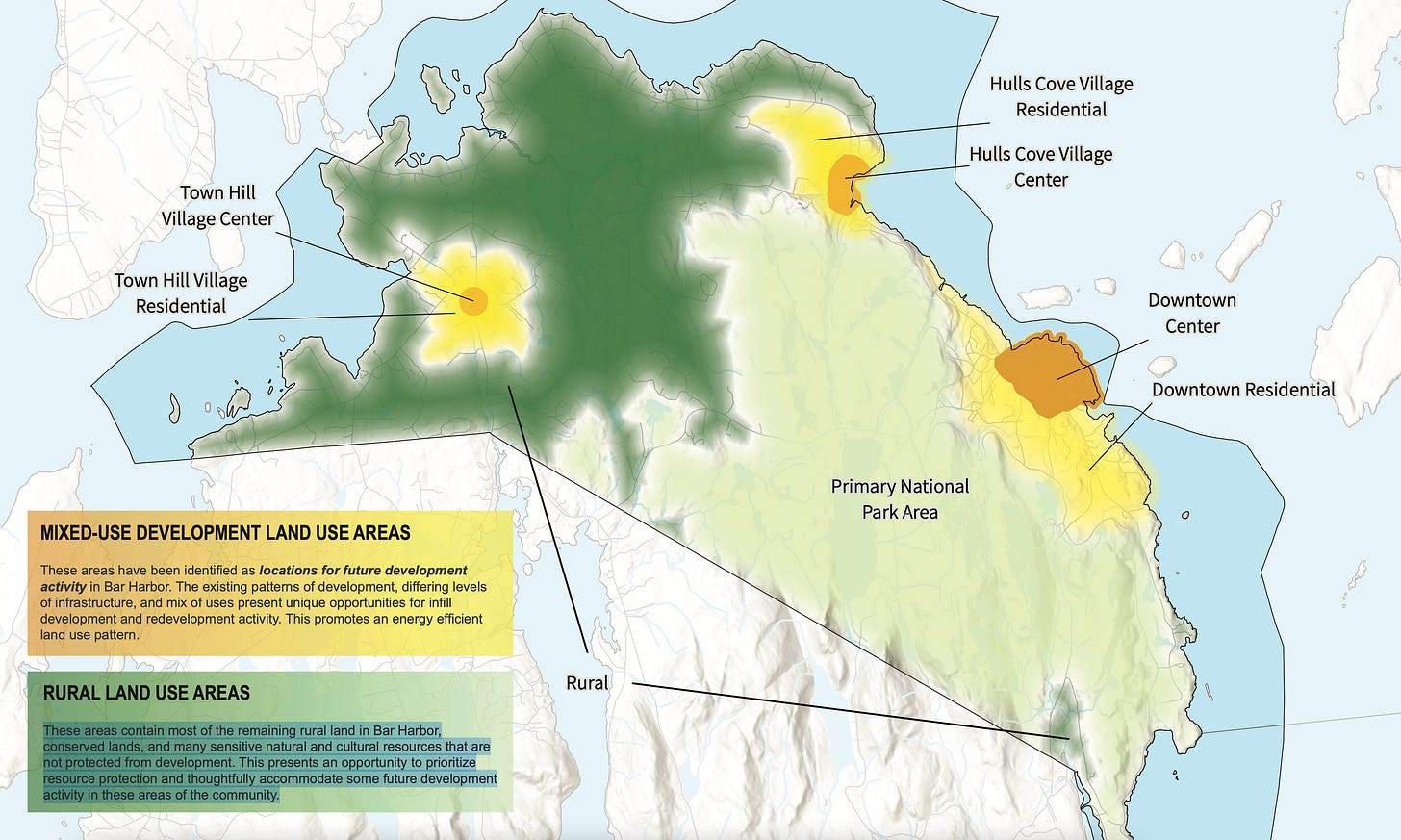
Both maps were broken down into two major zones of usage: “mixed-use development land use areas” and “rural land use areas.”
On the maps, mixed-use-development-land-use areas are defined as “these areas have been identified as locations for future development activity in Bar Harbor. The existing patterns of development, differing levels of infrastructure, and mix of uses present unique opportunities for infill development and redevelopment activity. This promotes an energy efficient land use pattern.”
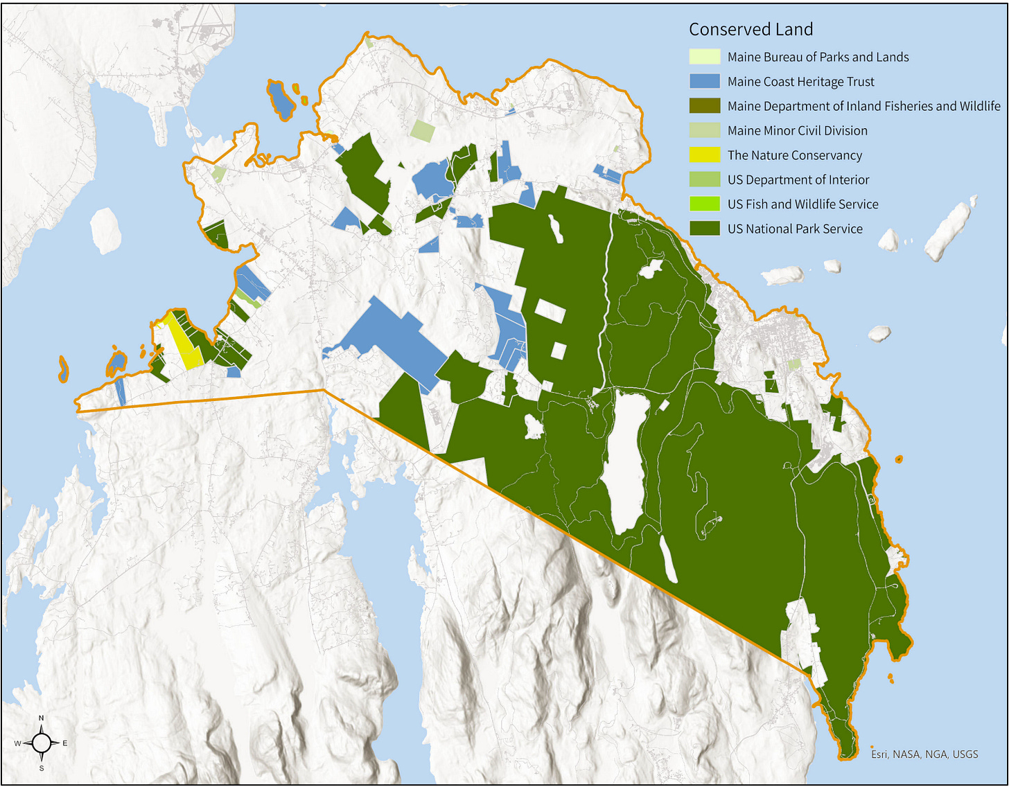
The rural-land-use areas are defined as “these areas contain most of the remaining rural land in Bar Harbor, conserved lands, and many sensitive natural and cultural resources that are not protected from development. This presents an opportunity to prioritize resource protection and thoughtfully accommodate some future development activity in these areas of the community.”
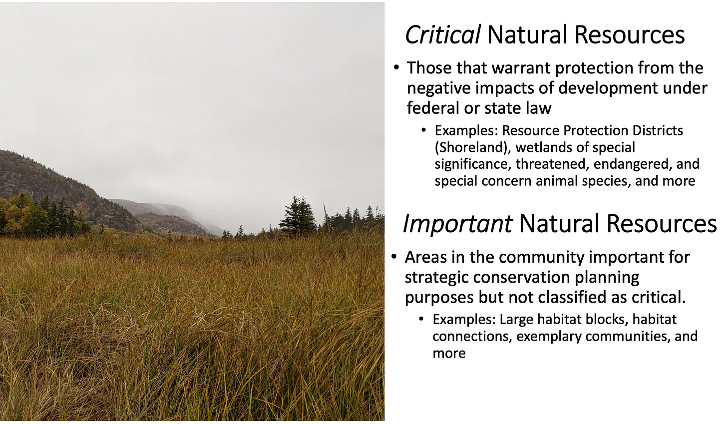
For future housing development, the question becomes how does the town maintain a balance between supporting housing expansion and saving natural resources.
The first map showed the three existing areas with the highest concentration of dwelling units, downtown, Hulls Cove, and Town Hill which were identified as the mixed-use-development-land-use areas.
The second map showed the same three existing areas (downtown, Hulls Cove, and Town Hill) but added a “potential additional residential area” in both the Salisbury Cove and Hadley Point areas. The additional potential residential areas are shown in areas that are marked as rural-land-use areas in Salisbury Cove and Hadley Point on the other map.
Salisbury Cove, Hadley Point, and Town Hill are not serviced by either town water or town sewer. This worried many of the attendees at the workshops who live in these areas. They were concerned primarily with the water supply, not just because of the additional strain that new development would put on the existing aquifers, but also because of the added risk of contamination by new septic systems in close proximity to those water supplies.
GROUND WATER
A 2004 study by Stratex Strategic Consulting, “Hydrogeologic Resource Evaluation Bar Harbor, Maine” focused on the health of Bar Harbor’s existing water sources and ensuring that future development does not harm or contaminate existing wells and/or deplete the underground water sources.
The results of Stratex’s study from the 2007 comprehensive plan (section V.H.) include the following statements.
“Based on its study, Stratex says that the town ‘is likely to have enough water to supply the needs of current dwellings as well as the dwellings predicted under the build-out scenarios for 2034’ with exceptions, particularly in areas where ‘well yield is marginal relative to bedrock fractures, soil type, and ground water recharge zones’ or under drought conditions. It also notes that ‘new development in close proximity to older wells, increased pumping near existing wells, or deep excavations such as rock quarries could impact water availability by lowering the ground water table beyond the reach of existing wells.’
“The study also points out that though the quantity of water may be adequate, the town may face a larger issue with respect to water quality because of contamination from residential storage of chemicals and petroleum and, especially, from onsite septic systems in marginal areas of thin soils, exposed bedrock, and vulnerable ground water recharge (topographic highs). Contaminants from septic systems include pathogens (bacteria and viruses) and elevated nitrate-nitrogen. Strategies to reduce these threats include ensuring sufficient separation distance between well and septic systems to increase water travel times and mixing of wastewater to reduce concentrations of nitrate- nitrogen to less than 10 mg/L at the wellhead. Other concerns include potential salt water intrusion from extensive pumping in a coastal setting and/or drought conditions.
“The study notes that records from 200 tests indicate a concentration of nitrate- nitrogen in private drilled wells of 0.6 mg/L on average, well below the maximum level of 10 mg/L. The maximum concentration reviewed was 7.9 mg/L, suggesting that a contamination source like a septic system or manure pile was nearby. The study notes that key findings from a review of the literature indicate:
· concentrations of nitrates-nitrogen increase with increased population/septic system density;
· a distance of 100 feet between wells and septic systems may not be adequate to protect well water from contamination by onsite septic systems; and
· a septic system density of less than one per 1⁄2 acre may not be adequate.
“The study suggests impacts can be minimized by requiring new subdivisions to demonstrate ‘no impact’ compared to an established standard and construct, site, install, and maintain systems well. Impacts of subdivisions could be increased by:
· decreased groundwater recharge potential from impervious surfaces;
· siting septic systems in recharge areas, thin soil, or exposed bedrock;
· improperly maintained septic systems;
· aging wells (with failing seals);
· replacement of natural forested and field areas with residential lawns;
· salt water intrusions of pumping of wells near the shore;
· addition of household chemicals to septic systems;
· improper storage of household chemicals and petroleum products; and
· disturbing topsoil during site construction.
“The most vulnerable areas of Bar Harbor include:
recharge zones (the upper third of a watershed);
areas of thin soils (less than five feet deep), soils with low recharge rates (5-
15%), and exposed bedrock; and
coastal areas within 200 feet of the shoreline.
Stratex recommended three approaches to addressing water quality concerns:
voluntary efforts to encourage individuals and groups to act responsibly including efforts like:
water conservation,
optimized well siting, denitrification equipment, and regular monitoring and
maintenance,
minimized site alterations,
preservation of large parcels, infill in areas served by public sewer and
water,
management of composting, pet waste, and harmful household products,
and
land conservation, all advanced by public education,
user and impact fees for water resource management to help recover costs to reduce impacts from those that create them, and
regulations for periodic water quality testing and maintenance and land management to preserve groundwater quality and quantity including loss of recharge; enhanced infiltration; lowering the water table beyond property boundaries; staying within safe yields; monitoring well installation, water quality in wells, and long-term groundwater level trends; preventing salt water intrusions, degradations from septic systems, and contaminations from household products.
“It also suggests that in some cases, developers may work with the town to provide public water or sewer systems where cluster development may be preferable to large lot development. Finally, Stratex recommends a number of action steps, including:
setting up a data base of wells and problem areas, linked to a GIS,
registering new wells,
developing a ground water model,
regularly reviewing water quality test data;
evaluating other potential threats to hydrogeologic resources,
preventing development on vulnerable areas,
GIS mapping of wells, the water supply system, vulnerable areas, aquifer
recharge areas, and rate of residential growth, and
developing procedures for developers to perform a hydrogeologic analysis,
and optimizing siting of wells, and refining the build-out analysis.”
A concern mentioned in the Stratex study, but probably not as fully realized in 2004, for aquifers is the risk of salt water intrusion during times of drought which will only be exacerbated by the effects of rising high tide levels due to climate change. Drilling wells in low lying areas close to the coast becomes a higher risk every day.
According to a study published June 15, 2023 in Geophysical Research Letters, humans have removed so much ground water from the Earth that we have actually caused its axis to tilt approximately 2.6 feet. The article says, “a climate model estimate for the period 1993–2010 gives total groundwater depletion of 2,150 GTon (gigatons), equivalent to global sea level rise of 6.24 mm. However, direct observational evidence supporting this estimate has been lacking. In this study, we show that the model estimate of water redistribution from aquifers to the oceans would result in a drift of Earth's rotational pole, about 78.48 cm toward 64.16°E.”
WASTEWATER (SEWER) PLANTS
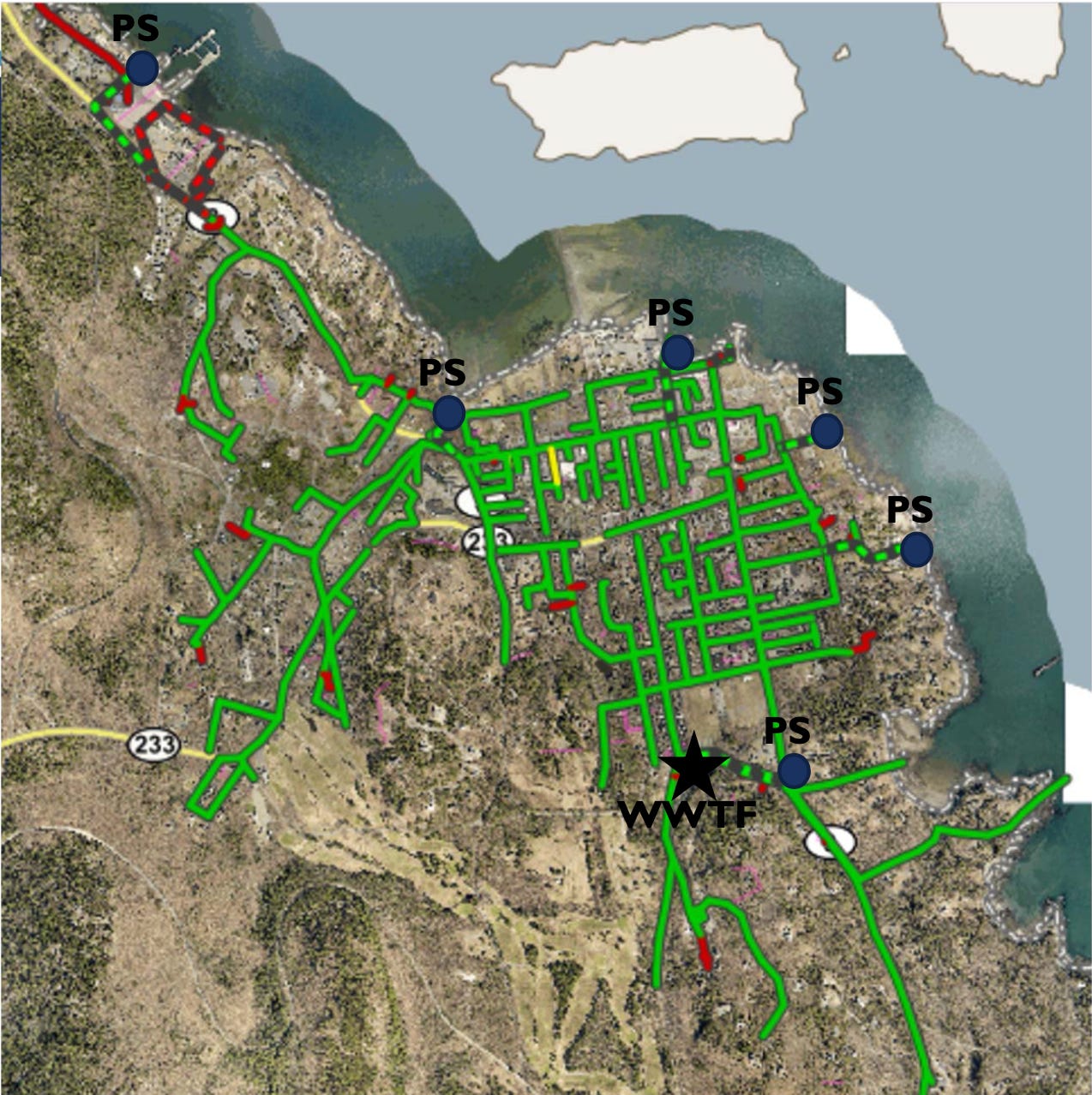
Bar Harbor has three wastewater treatment plants. The main plant is at the corner of Ledgelawn Avenue and Cromwell Harbor Road, a secondary plant at the Hulls Cove Highway Department headquarters property off of the Crooked Road, and a tertiary and small capacity plant at the bottom of DeGregoire Park Road.
The DeGregoire Park system is the smallest system and has a capacity of .015 million gallons per day (MGD). It serves a very limited amount of residences and is the only system that does not have a combined sewer overflows outlet. It is serviced by one pump station and has a 600 linear foot (LF) 8” outfall pipe.
It is fed by 2,800 LF of sewer mains and has an additional 480 LF of 6” forced mains. Forced mains are the pipes on the outlet side of the pump stations where wastewater is actually being pumped to the treatment plant.
The Hulls Cove treatment plant has a slightly higher capacity than the DeGregoire Park plant at .25 MGD. Its annual average daily use is approximately .05 MGD or one fifth of its capacity. Hulls Cove is serviced by four pump stations and has a 3,300 LF 8” outfall pipe. It also has a 420 LF 8” CSO pipe.
The pump stations are located at Ocean Avenue, Wilcomb Lane, the Public Works building campus, and Hulls Cove. The CSO outlet is at Hulls Cove and flows into Frenchman Bay.
The Hulls Cove plant is fed by 8,595 LF of sewer mains and an additional 3,000 LF of 6” forced mains.
Bar Harbor’s main treatment plant has a capacity of 5.2 MGD and a much more robust system of pumps and outlets. The main treatment plant’s annual average daily use is approximately 1.0 MGD or roughly one fifth of its capacity. It is serviced by six pump stations and has a 4,800 LF 24” outfall pipe. It also has three CSO outlets ranging in size from 12” to 24”. The three CSO pipes total 1,520 LF.
The pump stations for the main plant are located at the ferry terminal, West Street, Rodick Street, Albert Meadow, Hancock Street, and lower Main Street. The CSO outlets are located at West Street (flowing into Eddie Brook), Rodick Street (flowing into Frenchman Bay), and lower Main Street (flowing into Frenchman Bay).
The main treatment plant is fed by 12.9 miles of sewer mains that are less than 18” in diameter and 1.6 miles of trunk lines that are 18” or greater in diameter. In addition, it has 6,840 LF of forced mains.
Looking at the capacities of the sewer plants, the town’s average usage indicates that it is well below system capacities. Were these systems new and the town’s stormwater collection systems likewise new, the town would be in good shape for the use expansion created by new customers. However, little of the town’s system can be considered new or updated right now.
During heavy rain events, the town’s wastewater collection pipes can be overwhelmed with intruding stormwater. Normally, all of the wastewater that is released into the ocean from the town has been treated. This release of treated water occurs via the outfall pipes from both the main treatment plant and the Hulls Cove treatment plant. This normal operation, based upon the number of current users, keeps the amount of wastewater being processed well below the capacity of both plants, at approximately one fifth of their maximum capacities.
However, the introduction of great amounts of stormwater into the wastewater system can cause both plants to reach and exceed their operational capacities. The pump stations that pump wastewater to the plants will not pump more wastewater to the plant than the plant can successfully treat. When the amount of water, a combination of wastewater and stormwater, exceeds these maximum capacities the excess water flows untreated into the bay via the CSO pipes.
WHAT THE TOWN IS DOING NOW?
That is beginning to change. The town is, and has been, working towards remediating the issues that can cause CSOs. These issues include old wastewater pipes that were or have become permeable, failed seals on pipe systems, broken pipes, submerged manhole covers during flooding events, and sump pump and roof collection systems that are illegally tied in to the wastewater collection systems.
Both State of Maine DEP regulations and local regulations make it illegal to tie sump pump systems and roof collection systems in to the wastewater collection system.
Some of the remediation is a slow process of stumbling upon an issue, such as when a broken pipe is discovered or an illegal tie in to the wastewater collection system is found. Some of these illegal systems are very old and the current property owner or town may not even know they exist.
On a greater scale, the town is being proactive. Those bundles of large green pipes that are now shrink-wrapped in white plastic stacked in the dirt lot across the street from the Ledgelawn treatment plant are part of the solution to the CSO issue which will allow greater expansion of wastewater customers with a lowered threat of untreated CSO release into the bays.
Those pipes are for a project on lower Main Street that will start at Pleasant Street and run south to Cromwell Harbor Road. Within this project zone, the town will be replacing the wastewater pipes, stormwater pipes, and water mains. The larger diameter pipes to be installed will allow better flow capacities for stormwater and wastewater and will help reduce CSOs in this historically wet and easily flooded area of town.
This project is being paid for by a bond that was approved by voters in June 2022. According to Interim Town Manager and Finance Director Sarah Gilbert, the total bond amount will be over $50 million and will hopefully be sold in October.
In addition to the lower Main Street project, this bond will be used for other priority infrastructure, the Higgins Pit Solar Array, the internet fiber project, the new grammar school architectural plans, and refunding of older bonds from 2011 and 2013.
TOWN WATER
The Town of Bar Harbor has one public water supply, one water treatment plant for that supply, and the entire operation is 100% gravity fed. The system also includes two 500,000 gallon water tanks, one at the Duck Brook treatment plant and one near the Jackson Lab.
The output capacity is based upon the treatment capacity of the Duck Brook water treatment plant. The maximum output of the plant is 3.6 million gallons per day (MGD), but that is a scenario where the plant is running at full capacity for 24 hours a day. This is not a viable expectation and the realistic maximum output is 2.8 MGD.
The average daily water demand is approximately 1.0 MGD with a maximum daily demand (based upon the summer of 2022) of 2.6 MGD. According to the town, the average daily summer demand is below the maximum capacity and the water system can support an additional 500 gallons per minute or 560,000 gallons per day based on the realistic maximum output.
The town’s year-round water supply system runs from just south of the Jackson Lab through downtown and Hulls Cove and terminates just north of Pirates Cove Adventure Gold. There is a short section of seasonal supply system that starts at the DeGregoire Park Road and Route 3 intersection and terminates just north of Hadley Point Road.
Because the system is currently 100% gravity fed, expansion of the year round system beyond its current boundaries would be quite costly and would require the installation of pumps to move the water to elevations greater than 235’ and maintain water pressure. Beyond that, once the daily output capacity of the Duck Brook treatment plant is exceeded, a new or additional water treatment plant would need to be constructed.
In addition, much of the existing water main system is aged and undersized. Expansion would require replacement of much of that system (as is being done for the lower Main Street project) to provide capacity and pressure for a larger system. As stated above, replacement of parts of the system are underway as they often get replaced simultaneously with wastewater and stormwater pipe replacement.
According to a comprehensive master plan update summary completed by Oliver Associates Inc. and presented to the town council on September 15, 2020, residential properties, both year round and seasonally supplied, make up approximately 23.6% of the town supplied water usage. Commercial properties, both year-round and seasonally supplied, make up approximately 48.5% of the town supplied water usage.
According to that same report, “Around 40% of the water is consumed by ten major water users with the highest demand from Jackson Laboratory which uses about 23.3% of the water.” The report stated that in 2002 Jackson Laboratories used 44,148,538 gallons of water and in 2018, it used 60,749,149 gallons of water.
MAINE HOUSING LEGISLATION LD 2003
Water and sewer are not the only necessities for new dwelling unit construction, but they do represent the biggest dichotomy of available utilities. Does the town want to focus on making it possible to build in areas that have expandable infrastructure in place for town water and sewer or do they want to focus on areas that rely upon fragile and everchanging natural resources?
According to the town’s comprehensive planning page, “the purpose of the new Bar Harbor Comprehensive Plan is to reflect and respond to the needs, values, and priorities of the community while safeguarding Bar Harbor’s sense of place, history, and natural resources. The new plan will serve as a guide for future growth and development, covering subjects such as, but not limited to, land use, zoning, capacity and expansion of utilities, economic development, transportation, housing, recreation, capital budgeting, provision for municipal services and facilities, and regional coordination. The plan will also serve as a foundation for determining effective public policy, master planning, and land use decisions for the future.”
The land use ordinance changes that are mandated by LD 2003 should play a hearty role in the town’s new comprehensive plan regarding future development in relation to existing infrastructures, prevention of urban sprawl, and protection of our natural resources, including waterfront, shrinking rural areas and wildlife habitat, and underground water sources.
According to the website of the Southern Maine Planning and Development Commission, (SMPDC) “LD 2003 was passed by the State Legislature and signed by the Governor in April 2022. The law went into effect July 27, 2022, however, the bill’s requirements do not take effect until July 1, 2023.”
LD 2003 requires municipalities of over more than 4000 residents to make certain changes to their land use ordinance to increase housing opportunities. A synopsis from the SMPDC webpage states,
“The goal of the new law is to alleviate the housing affordability issues in Maine by increase(ing) housing opportunities.
“It requires towns and cities to increase housing density allowed in their zoning ordinances in several different ways.
It requires municipalities to allow additional units on lots zoned for single-family homes.
It requires municipalities allow at least one accessory dwelling unit on lots with existing single-family homes.
In some areas, (see below) it requires municipalities to allow 2 1/2 times the currently allowed housing units, for developments where most of the units meet standard affordability definitions.
“The extent of the law’s requirements are determined by “growth areas”. The law defines a growth area as:
Locally designated growth areas identified in a comprehensive plan which meets consistency guidelines of the Growth Management Program or (in the absence of a consistent comprehensive plan)
an area served by a public sewer system with capacity for a growth-related project,
an area identified in the most recent Decennial Census as a census-designated place, or
a compact area of an urban compact municipality.”
According to themainewire.com, another bill, LD 1706, was passed in June of this year that gave municipalities an extension to meet the requirements of LD 2003. From themainewire.com, “in light of LD 1706, however, ‘municipalities for which ordinances may be enacted by the municipal officers without further action or approval by the voters of the municipality’ have until January 1, 2024, to make the necessary changes, and all other municipalities have until July 1, 2024.”
When asked how the town was progressing towards meeting the requirements of LD 2003, Town Planning Director Michele Gagnon said, “The rules took a while to come out and many things were in flux, in the last session there were several bills proposing amending the original bill. DECD (Department of Economic and Community Development) held a series of workshops until about 2 months before the implementation deadline of July 1(2023). Overall, I think the concept has great merit. In a town like Bar Harbor, with 40 zoning districts, it is a daunting task to incorporate this language into the land use ordinance. We have been making progress and are looking to be able to meet the July 1, 2024, deadline.”
In September 2021, the town sent out a request for proposal (RFP) to consulting firms who might be interested in being the consulting firm for the new comprehensive planning process. That RFP contained a timeline of events with November 17, 2021, being the work start date for whatever firm was chosen. That timeline also said that on December 1, 2022, the final draft plan and executive summary “MUST” be completed. Further, the timeline said that on February 1, 2023, the final plan and executive summary “MUST” be completed.
The RFP also contained a budget and the town stated that they were estimating that they would have to spend $100,000 to complete the process.
The town eventually chose Resilience Planning and Design to be the firm that would help guide the town through the comprehensive planning process. At a December 20, 2022, town council meeting, Planning Director Michele Gagnon made the case for more time and more money to complete the comprehensive planning process.
Gagnon said, “Bar Harbor is absolutely unique. It is not like any municipal towns they (Resilience Planning and Design) have seen: coastal or not coastal, resort or not resort.” The town council unanimously approved spending an additional $100,000 on the comprehensive planning venture. $50,000 of that money was taken from line items that had a surplus and the other $50,000 was approved at Town Meeting this past June.
Along with the request to double the money spent, a request was made to double the allotted time spent on the project, extending it from 12 months to 24 months.
This article has been updated because I, Carrie, put a typo in the subhead. Apologies. I noticed it the moment I hit SEND, of course. Actually, Shaun noticed it the moment I hit SEND.






Lotta content, nicely organized. Well done, Shaun.
Shaun,
Thanks so much for the summary of current planning activities. The Comprehensive Plan public information meeting provided too much information to absorb at the time. Also it is great to have an overview of the local waste water and fresh water systems problems and upgrades. And the discussion and links to LD2003 were very informative. This all makes me realize how complicated the Bar Harbor development efforts are.