BAR HARBOR, MAINE – To ensure the safety of park visitors, the National Park Service (NPS) will close several areas of Acadia National Park on Friday, September 15, in preparation for Hurricane Lee.
On Friday at 5:00 pm, the Park Loop Road from the Sand Beach Entrance Station to the end of the one-way section at Stanley Brook Road, and the one-way section of the Schoodic Loop Road starting at Frazer Point will be closed to motor vehicles until further notice.
All park campgrounds will close on Friday at 10:00 am, including Blackwoods, Seawall, Schoodic Woods, and Duck Harbor (Isle au Haut) until further notice.
As a result of the closures, some of the Island Explorer bus service will be disrupted. There will be no service starting on Friday until further notice on the Blackwoods (#10), Tremont (#11), and Schoodic (#8) routes. There will be no service starting at 5 pm on Friday until further notice on the Sand Beach (#3) and Loop Road (#4) routes. During this time, the Southwest Harbor (#7) route will terminate and turn around at Manset. For more information, please visit the Island Explorer website (exploreacadia.com).
As the storm subsides, the NPS will assess safety conditions and reopen these areas as soon as possible.
Visitor safety is the National Park Service’s top priority. Visitors should stay back from the ocean’s edge to avoid rogue waves that can wash people out to sea even in the aftermath of the storm. Visitors should also be aware of high winds that can cause trees and branches to fall. Visitors should exercise caution while visiting the park throughout the weekend.
Information on current conditions is available on the park's website and social media.
OTHER UPDATES
According to the National Weather Service,
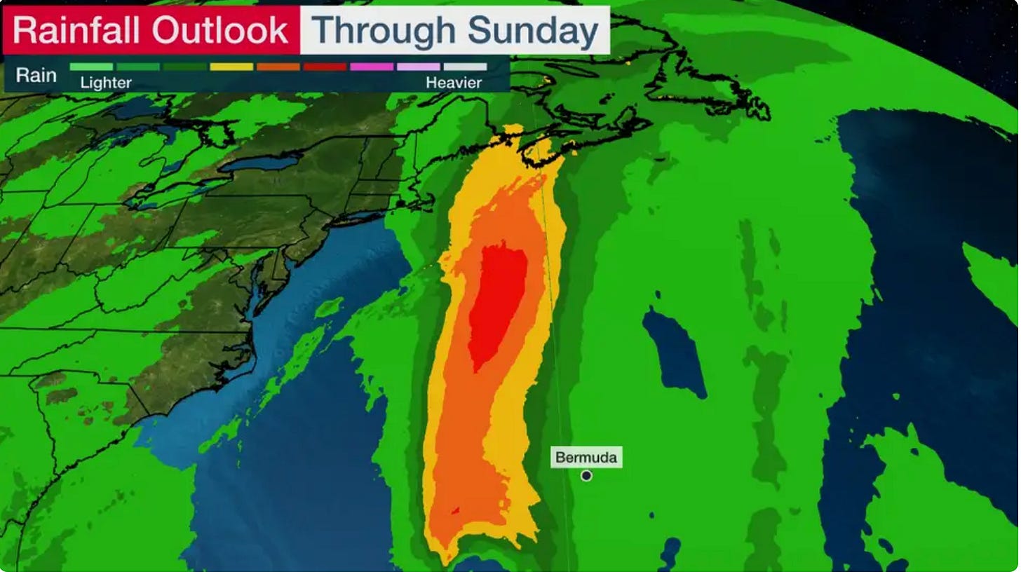
”Hurricane Lee will continue to track north over the next couple of days, moving west of Bermuda late today and early Friday, before tracking east of southern New England on Saturday. Due to the large size of the system, hazards will extend well away from the center. This includes tropical storm conditions which are possible in portions of coastal New England, including Cape Cod, Nantucket, Martha's Vineyard, and Block Island beginning Friday night. By early Saturday, tropical storm conditions are expected to reach as far north as Down East Maine. As the storm tracks north, there is the potential for life-threatening storm surge flooding in portions of southeastern Massachusetts, including Cape Cod and Nantucket late Friday and Saturday. Swells generated by lee continue to affect much of the East Coast -- producing life-threatening surf and rip current conditions.”
A National Weather Service update that covers Hancock County states:
Hurricane Local StatementAlert:
This product covers EASTERN AND NORTHERN MAINE

**Hurricane Watch and Tropical Storm Watch Continues for Downeast Maine
as Lee Approaches**
NEW INFORMATION
---------------

* CHANGES TO WATCHES AND WARNINGS:
- A Tropical Storm Watch has been issued for Northern Washington

* CURRENT WATCHES AND WARNINGS:
- A Hurricane Watch is in effect for Coastal Hancock and Coastal
Washington

- A Tropical Storm Watch is in effect for Central Washington,
Interior Hancock, Northern Washington, and Southern Penobscot

* STORM INFORMATION:

- About 1050 miles south of Petit Manan ME or about 1090 miles
south of Eastport ME
- 29.1N 68.1W
- Storm Intensity 100 mph
- Movement North or 350 degrees at 9 mph

SITUATION OVERVIEW
------------------
- Forecaster confidence continues to increase that Lee will make
landfall just east of the coast of Maine late Saturday or Sunday

- Large pounding surf is almost a definite at this point with coastal
and marine impacts expected to begin as early as late tonight

- Persons along the coast should be planning for a strong tropical
storm or category 1 hurricane. The greatest potential for the
hurricane force wind gusts is across coastal Washington County

- Tropical storm impacts will extend inland from the coast

POTENTIAL IMPACTS
-----------------

* WIND:

Prepare for dangerous wind having possible significant impacts across
coastal Downeast Maine. Potential impacts in this area include:

- Some damage to roofing and siding materials, along with damage
to porches, awnings, carports, and sheds. A few buildings
experiencing window, door, and garage door failures. Mobile
homes damaged, especially if unanchored. Unsecured lightweight
objects become dangerous projectiles.

- Several large trees snapped or uprooted, but with greater
numbers in places where trees are shallow rooted. Several
fences and roadway signs blown over.

- Some roads impassable from large debris, and more within urban
or heavily wooded places. A few bridges, causeways, and access
routes impassable.

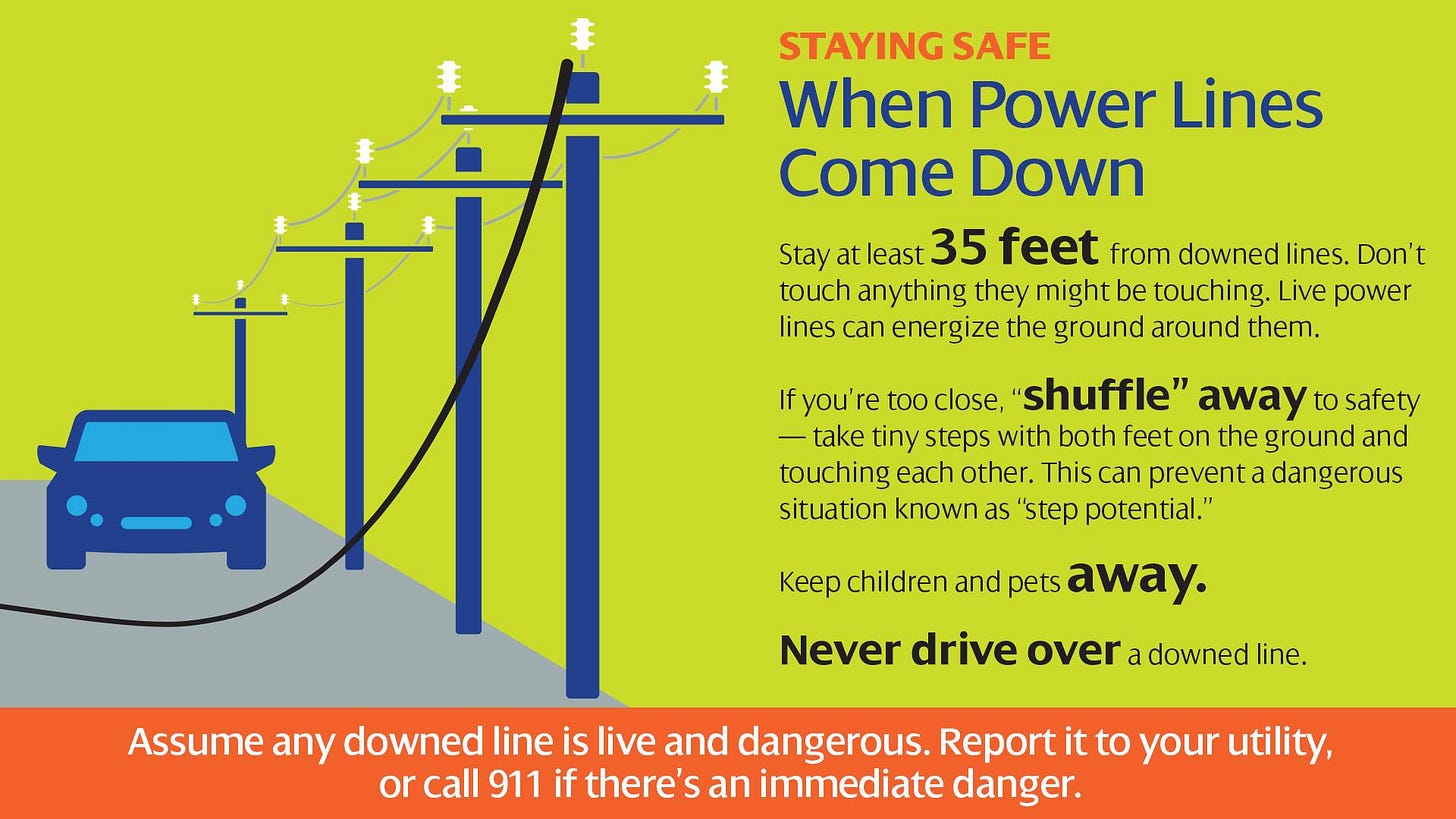
- Scattered power and communications outages, but more prevalent
in areas with above ground lines.

Also, prepare for hazardous wind having possible limited impacts
across Interior Downeast Maine and the Bangor Region.

* SURGE:
Prepare for locally hazardous surge having possible limited impacts
across coastal Downeast Maine. Potential impacts in this area include:

- Localized inundation with storm surge flooding mainly along
immediate shorelines and in low-lying spots, or in areas
farther inland near where higher surge waters move ashore.
- Sections of near-shore roads and parking lots become overspread
with surge water. Driving conditions dangerous in places where
surge water covers the road.
- Moderate beach erosion. Heavy surf also breaching dunes, mainly
in usually vulnerable locations. Strong rip currents.
- Minor to locally moderate damage to marinas, docks, boardwalks,
and piers. A few small craft broken away from moorings.

* FLOODING RAIN:
Prepare for dangerous rainfall flooding having possible significant
impacts across Downeast Maine. Potential impacts include:

- Moderate rainfall flooding may prompt several evacuations and
rescues.

- Rivers and tributaries may quickly become swollen with swifter
currents and overspill their banks in a few places, especially
in usually vulnerable spots. Small streams, creeks, canals,
arroyos, and ditches overflow.

- Flood waters can enter some structures or weaken foundations.
Several places may experience expanded areas of rapid
inundation at underpasses, low-lying spots, and poor drainage
areas. Some streets and parking lots take on moving water as
storm drains and retention ponds overflow. Driving conditions
become hazardous. Some road and bridge closures.

* TORNADOES:
Little to no impacts are anticipated at this time across EASTERN AND
NORTHERN MAINE.
PRECAUTIONARY/PREPAREDNESS ACTIONS
----------------------------------

* EVACUATIONS:
Listen to local official for recommended preparedness actions,
including possible evacuation. If ordered to evacuate, do so
immediately.

* OTHER PREPAREDNESS INFORMATION:
Now is the time to check your emergency plan and emergency supplies
kit and take necessary actions to protect your family and secure your
home or business.

When making safety and preparedness decisions, do not focus on the
exact forecast track since hazards such as flooding rain, damaging
wind gusts, storm surge, and tornadoes extend well away from the
center of the storm.

If in a place that is vulnerable to high wind, such as near large
trees, a manufactured home, upper floors of a high-rise building, or
on a boat, plan to move to safe shelter.

If you live in a place particularly vulnerable to flooding, such as
near the ocean or a large inland lake, in a low-lying or poor
drainage area, in a valley, or near an already swollen river, plan to
move to safe shelter on higher ground.

Always heed the advice of local officials and comply with orders that
are issued. Do not needlessly jeopardize your life or the lives of
others.

If you are a visitor, know the name of the county in which you are
located and where it is relative to current watches and warnings. If
staying at a hotel, ask the management staff about their onsite
disaster plan. Listen for evacuation orders, especially pertaining to
area visitors.

Closely monitor weather.gov, NOAA Weather Radio and local news
outlets for official storm information. Listen for possible changes
to the forecast.

* ADDITIONAL SOURCES OF INFORMATION:
- For information on appropriate preparations see ready.gov
- For information on creating an emergency plan see getagameplan.org
- For additional disaster preparedness information see redcross.org
NEXT UPDATE
-----------
The next local statement will be issued by the National Weather
Service in Caribou ME around 11 AM EDT, or sooner if conditions
warrant.
POWER OUTAGES LIKELY
According to a piece in the Portland Press Herald by Todd Gunther,
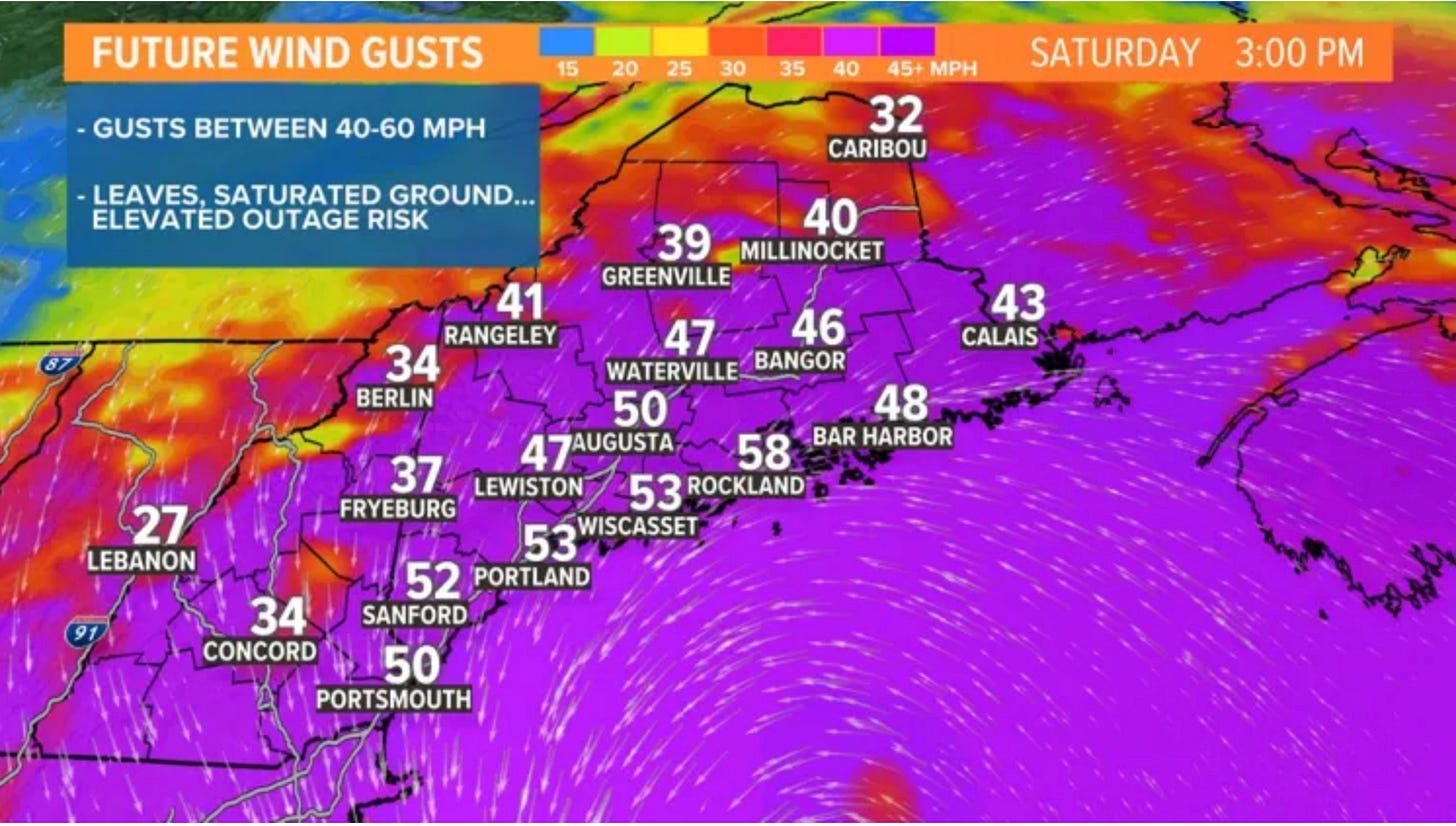
“Our threshold for power outages will be much lower than a winter Nor’easter, when leaves are off trees and the ground is frozen solid, cementing in root systems. Leaves add weight and act like sails, and our soil is saturated. I’d guess that gusts around 40 or 45 mph may be that line when outages begin to occur. At this time, I’m expecting gusts between 40-60 mph, so obviously people are going to lose power…how many is still up in the air. There is also a chance that a section of Down East could receive gusts higher than 60 mph, but this is highly track dependent and won’t be known until we get closer.”
Gunter also said that Lee should weaken as it heads through the Gulf of Maine. This is because of the colder ocean water. Though that could potentially make the hurricane feel more like a Nor’easter, it could still cause power outages, a good amount of inland flooding, and erode beaches.
Sodden ground prior to the storm’s arrival also increases the potential for flooding.
Bar Harbor Fire Chief Matt Bartlett was interviewed on the national news about the upcoming storm. One of the many things he stressed was to stay away from the waves.
The National Hurricane Center has said, “Lee is expected to remain a large and dangerous hurricane for the next couple of days.”
Detailed maps and updates are here at the Weather Channel.
LINKS TO LEARN MORE
Our last story has some emergency preparedness steps and discussion:
Bar Harbor Public Safety (police, ambulance, fire): 207-288-3391
Hancock County Emergency Management Facebook Page or 207) 667-8126
ema@hancockcountymaine.gov or hancockcountymaine.gov/emergencymanagement


